Guide author: Thomas Duke
Photography: As noted
This guide will take you to all the good photo points along the Beesley’s Secondary Track in Camden and Atlantic Counties in South Jersey. This trackage hosts an afternoon-weekday local round-trip to Winslow Junction NJ. Also 2 or 3 times a week, coal trains run to the generating station in Palermo NJ, outside Ocean City.
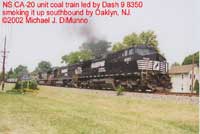
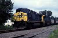
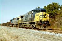
Trains start out on the Beesley’s Secondary at CP-BROWN in South Camden. This location isn’t a great place to be alone. You can get shots and get out, but try not to make yourselves stand-out as railfans. Therefore, you’d be better off making your first shot at Collingswood or Oaklyn, along Atlantic Avenue. The photo at left is at Oaklyn. Photograph: Mike DiMunno
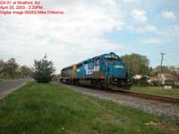
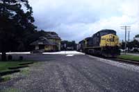
Atlantic runs parallel from MP3 to MP12 so you’ll always be within sight. Audubon station, Haddon Heights station are located along the street, and can be worked into a photo. The photograph at left is at Haddon Heights station. Photograph: Tom Duke.
A traffic light is being installed in November 2003, and this might delay your train chase, it may not allow any traffic while the train is crossing. The next two traffic lights turn all-red while a train is here, so you will lose time at both intersections. Magnolia station is next, with a park on the grounds. This is the last depressing traffic light you have to deal with. The photograph at left is at Magnolia station. Photograph: Mike DiMunno.
Good shots also can be had at two locations near Stratford Ambulance and a swim club.
Unfortunately, you would have to scout while leading a train and choose only one location from Haddon Heights to Clementon. If you do shoot at Oaklyn, you can get ahead further down the line.
It should be noted that CSAO local CA-51 works local industries along this line Monday-Friday. This local works Weyerhaeuser Paper at Barrington, so if you choose a location north of Barrington, you then have plenty of time to get to the Stratford Ambulance or the swim club, or any location south of there while they do their work (Curt Hudson, 9-23-2009).
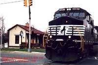
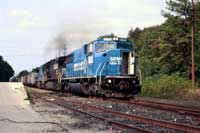
The photograph at left is by the Stratford Ambulance. Photograph: Mike DiMunno.
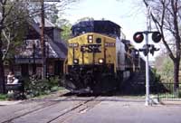
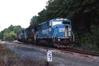
There’s a MofW siding at Lindenwold MP12 which is a decent photo. The photograph at left is at that MOW siding. Phorograph: Tom Duke.
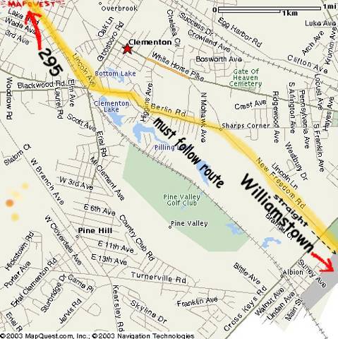
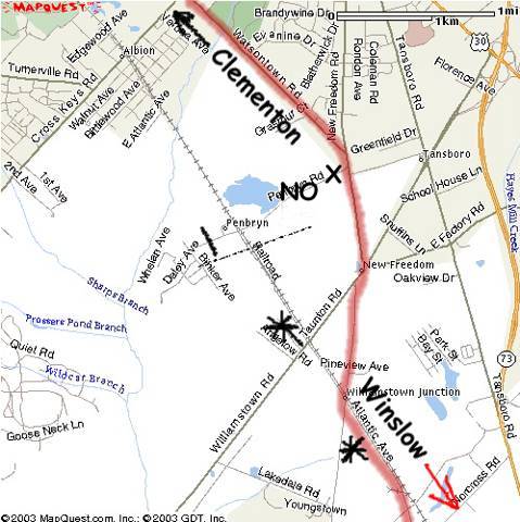
The fun really starts in Clementon, when you’ll have to leave the tracks and take other roads. The trick is NOT to turn right, but STRAIGHT into a one-way street,, and then a LEFT past Clementon Amusement Park. You’ll know this road when you see a shopping center at a T-intersection. At the first traffic light past the park, turn RIGHT onto Watsontown-New Freedom Road. It’s a graudual right at this traffic light. Continue on this road, skipping Cross-Keys Road, until coming to a Produce stand and a stop sign. Turn RIGHT here. Pembryn Road leads to a crossing, but is not a shooting location, and is a dead-end. Continue following the railroad and turning a gradual RIGHT again, at a garden center. Staying on this road (536) will lead to Johns Manville company and a PRSL freight dock.
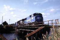
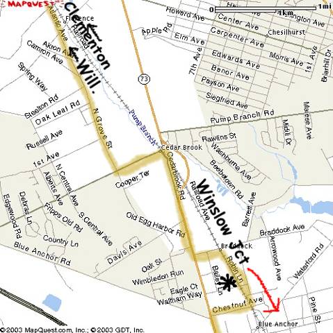
This next great photo location is Williamstown Junction. Both locations are good, but I like the freight dock. The photograph at left is at that freight dock. Photograph: Tom Duke.
Continuing parallel along the railroad will take you to a location at two company rail spurs. Stay straight on this fast road, turning LEFT only upon reaching Cedarbrook Road. This road will lead to a crossing that is not good for photos. BEFORE the crossing here, turn right and continue onto Route 73 South. Braddock Road appears quickly on the left after a mile or two, and leads to a parallel one-lane street. The photograph at left is along that one lane street in Braddock. Photograph: Tom Duke.
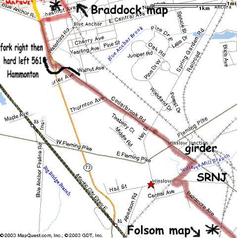
After this location, go back to Route 73 and find a LEFT jughandle LEFT turn onto 561 toward Hammonton. This is the road that passes Winslow Junction of the SRNJ. You can wait here for the train to cross the girder bridge above SRNJ or turn right and head toward Bairdmore Ave. where the interchange track is. You'll need to take Bairdmore Ave anyway to get to Folsom. The photograph at left is at Bairdmore Avenue. Photograph: Tom Duke.
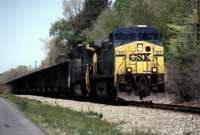
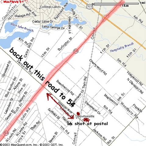
The sequence of roads is Bairdmore, 15th , 2nd and then 14th, leading to a model railroad shop, and a photo stop. From Bairdmore to Folsom is RIGHT, curve left and then a RIGHT turn. Keep chasing and turn right onto Route 54 South. You can head in Jackson Road for a photo at the Newtonville Post Office, but you’ll have to come back to Route 54. At the end of Route 54, turn left and then a quick right onto Tuckahoe Road (557) and leans to Milmay siding, and 7-mile straightaway. This is self-explanatory. Tuckahoe Road is very fast and you can take 6 or 7 series of shots in this 7-mile distance. The photograph at left is of a coal train parked on Milmay siding. This happens relatively frequently when the plant is full. Photograph: Tom Duke.
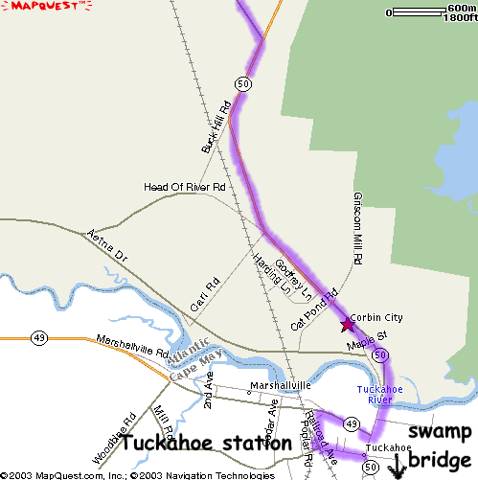
You’ll lose the tracks down the road, but going south on Route 50 will lead to Route 49 and Tuckahoe station. Turn right onto Route 49 and then look for a left turn before the road bridge over the tracks. The photograph at left is at Tuckahoe station. Photograph: Tom Duke.
After the Tuckahoe scene, the last location is the swamp bridge on Route 50, in a place called Petersburg. The bridge next to Route 50 goes over Cedar Swamp, and there are fishermen parked here, usually. The photograph at left is on the Cedar Swamp bridge. Photograph: Tom Duke.
County maps with railroads help tremendously, so you can study the turns. As a rule you will get lost without a map or this guide. This typed guide should always compliment the maps you have. Please see below for some accompanying maps that may help you in your persuit.
ACCOMPANYING MAPS
Map 1: Clementon to Albion
Map 2: Albion to Williamstown
Map 3: Williamstown to Braddock
Map 4: Braddock to Winslow
Map 5: Newtonville Area
Map 6: Tuckahoe and Cedar Swamp
This concludes the Beesley Point Secondary train-chaser's guide.